Appearance
1.5 — Plate Tectonics: The Idea and the Engine
In 1912 a thirty-one-year-old German meteorologist named Alfred Wegener stood up at a scientific meeting in Frankfurt and said that the continents move.
He had noticed, as schoolchildren notice, that the bulge of Brazil fits the hollow of West Africa. Unlike schoolchildren, he then went and collected the evidence. Identical fossil plants and reptiles on both sides of the Atlantic — Mesosaurus, a freshwater reptile that could not possibly have swum an ocean; Glossopteris, a seed fern whose seeds were far too heavy to blow across. Mountain ranges that end at the coast of Scotland and start again in Newfoundland with the same rocks in the same order. Coal seams in Britain, which need tropical swamps, and glacial scratch marks in India, Australia and South Africa, which need ice sheets — both dating from the same period. Reassemble the continents into one landmass, which he called Pangaea, and every one of those problems disappears at once.
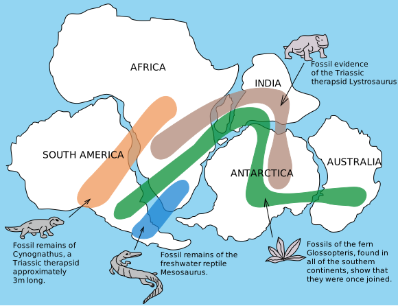
He was right, and he was rejected for fifty years. Not out of stupidity, and it is worth being precise about why, because the reason is a lesson in how science actually works. Wegener had no mechanism. He suggested continents ploughed through the ocean floor, pushed by tidal forces and by the Earth's rotation, and physicists calculated correctly that those forces are millions of times too weak, and that granite ploughing through basalt would shatter. The objection was legitimate. A pattern with no possible cause is a puzzle, not a theory. Wegener died on the Greenland ice cap in 1930, aged fifty, on an expedition to measure ice thickness, with his idea still in disrepute.
The mechanism turned up thirty years later, from an unexpected direction: the military mapping the sea floor.
What the sea floor gave away
The Second World War and then the Cold War put enormous effort into knowing the oceans, because submarines hide there. Sonar mapping and magnetic surveys, done for anti-submarine warfare, produced three findings nobody was looking for.
First, there is a mountain range running down the middle of the Atlantic, 65,000 kilometres long in total around the globe, with a rift valley along its crest. This is the mid-ocean ridge, and it is the largest single geological feature on the planet, entirely underwater and entirely unknown before the twentieth century.
Second, the sea floor is young and it gets older with distance from the ridge, symmetrically on both sides. Rock at the ridge crest is being formed now. Rock at the continental margins is up to about 200 million years old. Nothing anywhere on the ocean floor is older than that, on a planet 4.5 billion years old.
Third, and this is the decisive one: the magnetic stripes. Recall from Chapter 1.3 that cooling lava locks in the direction of the magnetic field at the moment it cools, and that the field reverses every few hundred thousand years. Magnetic surveys towed behind ships found that the ocean floor is striped — bands of normal magnetisation alternating with bands of reversed magnetisation, running parallel to the ridge.
And the pattern is mirror-symmetric about the ridge axis. The sequence of wide and narrow stripes going east matches the sequence going west, stripe for stripe.
There is only one way to get that. New crust is being made continuously at the ridge and carried away from it in both directions, like two conveyor belts running in opposite directions, recording the magnetic field of the moment it solidified. The stripes are a tape recording, and it plays the same in both directions because both sides were written by the same recorder. This was published by Fred Vine and Drummond Matthews in 1963, and by Lawrence Morley independently, and it is one of the cleanest pieces of evidence in the history of science.
Which raises the immediate problem: if new sea floor is made continuously, and the Earth is not expanding, then somewhere sea floor must be destroyed.
It is. Around the rim of the Pacific especially, there are deep trenches, and beneath every trench, earthquakes trace a plane of activity sloping downward into the mantle to depths of up to 700 kilometres. That sloping plane is a slab of ocean floor going down. Made at the ridge, destroyed at the trench. By 1968 the whole theory was assembled, and Earth science was rewritten inside a decade — one of the fastest complete reversals of scientific consensus on record, and it happened because the evidence became overwhelming, not because anybody was persuaded by argument.
The plates

The rigid outer shell of the Earth is broken into about fifteen major pieces and many smaller ones. The rigid shell is not the crust. It is the lithosphere — the crust plus the coldest, stiffest top part of the mantle welded to it, typically 100 kilometres thick under oceans and up to 250 under old continents. Beneath it is the asthenosphere, mantle rock that is hot enough to be weak and to flow, which is what the plates slide over.
A plate is defined by its edges, not by what is on it. The Indian plate carries India and a large area of Indian Ocean floor. The African plate carries Africa and part of the Atlantic. Coastlines are not boundaries, which is exactly why the Atlantic has no earthquakes along its shores and the Pacific has them along all of its shores.
Speeds are of the order of 2 to 10 centimetres per year — about as fast as a fingernail grows. GPS stations now measure this directly and continuously; the plate motions in a modern textbook are measured, not inferred.
The three kinds of boundary
Everything that happens geologically at the surface happens because of what plates do at their edges, and there are only three options: move apart, move together, or slide past.
Divergent — plates moving apart
Two plates pull away, the pressure on the mantle beneath drops, and the mantle melts simply because the pressure fell. This is worth pausing on, because it is unintuitive: the rock did not get hotter, it got less squeezed, and reducing pressure lowers the melting point. It is called decompression melting and it is where most of the Earth's magma comes from. The melt rises, fills the gap, freezes as new basalt, and the process repeats.
In the ocean this builds the mid-ocean ridge and produces new sea floor. On land the same process is tearing East Africa apart right now along the East African Rift, and if it continues, the Horn of Africa will separate. The Red Sea is a rift that got far enough along to flood — it is an ocean in its infancy, with genuine sea floor spreading down its middle.
Convergent — plates moving together
Three cases, depending on what is colliding, and they produce three completely different landscapes.
Ocean meets continent. Ocean crust is denser, so it dives beneath — this is subduction. The descending slab drags ocean water and hydrated minerals down with it. At about 100 kilometres depth, that water is squeezed out into the hot mantle above the slab, and adding water to hot rock lowers its melting point sharply, so the mantle wedge melts. That magma rises through the overriding continent, picks up silica from the continental crust on the way, and erupts as a chain of explosive volcanoes parallel to the coast. This is the Andes, and it is also why the Pacific rim is called the Ring of Fire.
Ocean meets ocean. Same mechanism, but the volcanoes come up through water and build a curved chain of volcanic islands: Japan, the Philippines, the Aleutians, Indonesia, the Caribbean arc. The trench sits on the outside of the curve. The deepest point in the ocean, the Mariana Trench at about 10,900 metres, is one of these.
Continent meets continent. Now neither side will go down, because continental crust is too buoyant — it cannot be forced into the mantle any more than a cork can be forced to the bottom of a swimming pool and left there. So the crust has nowhere to go except up and sideways. It crumples, thickens, and stacks itself into the largest mountains on Earth. This is the Himalaya, and Chapter 1.8 covers it properly.
Transform — plates sliding past
No crust made, none destroyed, just two plates grinding laterally. The rock does not slide smoothly; friction locks the fault until stress overcomes it, and then it lurches. Transform boundaries make earthquakes without volcanoes. The San Andreas Fault in California is the type example, and the North Anatolian Fault in Turkey is the other famous one.
The engine: what actually moves them
For a long time the standard picture was convection cells in the mantle, dragging plates along on their backs like objects on a conveyor. That picture is now known to be at best a partial answer, and the honest modern account gives three forces with very different weights.
Slab pull is the big one, contributing most of the driving force. When ocean lithosphere is old, it is cold and dense — denser than the hot mantle beneath it. Once it starts to sink, it keeps sinking under its own weight, and it drags the rest of the plate behind it like a tablecloth sliding off a table. The evidence is direct: plates with long subduction zones on their edges — Pacific, Nazca, Cocos — move several times faster than plates with none, such as the African and Antarctic plates, which are nearly stationary. Speed tracks how much slab a plate has hanging off it.
Ridge push is real but modest. New lithosphere at a ridge is hot and stands high; as it moves away it cools, contracts, gets denser and sinks lower. The plate is therefore sitting on a gentle slope, and gravity gives it a lateral shove. This is a genuine force but a minor one — perhaps a tenth of slab pull.
Basal drag from mantle convection can help or hinder. The mantle does convect, and where the flow beneath a plate happens to run the same way, it assists; where it runs the other way, it resists.
The honest summary is that plate tectonics is mostly gravity. Cold dense slabs falling into the mantle are the primary engine, and mantle convection is as much a consequence of that falling as a cause of it. The Earth is a heat engine converting its interior heat into surface motion, and the plates are the top of that circulation.
Hotspots: the exception that proves the rule
Some volcanoes are nowhere near a plate boundary. Hawaii sits in the middle of the Pacific plate. Iceland sits on a ridge but is far more volcanic than a ridge should be. Yellowstone sits in the middle of a continent.
These are hotspots, fed by plumes of unusually hot material rising from deep in the mantle, in many cases from the edges of the great blobs at the core-mantle boundary described in Chapter 1.3. The plume stays roughly fixed while the plate slides over it, so it punches a hole, the plate carries that volcano away, and a new one forms behind it.
The result is a chain of volcanoes in a line, getting older with distance. The Hawaiian chain runs northwest from the Big Island, which is erupting today, through progressively older and more eroded islands, then through drowned seamounts, then bends sharply north and continues as the Emperor Seamounts all the way to the Aleutian trench, where the oldest are about 80 million years old and about to be subducted. Read that chain as a tape and it records the direction and speed of Pacific plate motion for 80 million years, including a change of direction about 47 million years ago that produced the bend.
The supercontinent cycle
Pangaea, which Wegener reconstructed, assembled about 335 million years ago and began breaking up about 175 million years ago. It was not the first. Rodinia existed about a billion years ago, Columbia before that, and there are traces of earlier ones.
The cycle appears to run on a rhythm of roughly 400 to 600 million years, and there is a plausible mechanism for why it repeats. A single large continent acts as a thermal blanket, since continental crust is rich in radioactive elements and poor at letting heat through. Heat builds beneath it, the continent domes up, rifts, and splits. The fragments drift apart, the ocean between them widens, the ocean floor on their far sides ages and gets dense and starts subducting, and the fragments are eventually pulled back together on the other side of the world.
This matters for the rest of this volume more than it sounds. Supercontinents have terrible climates — vast dry interiors far from any ocean, extreme seasons, and low sea levels. Their breakups flood continental shelves with shallow warm sea, which is where most marine life lives, and they open new ocean routes that reorganise currents and climate. The breakup of Pangaea is directly responsible for the Atlantic Ocean existing, which is the ocean across which the whole story in Part 8 is sailed.
Where this shows up in your life
Where you can safely build. Every seismic building code on Earth is a map of plate boundaries turned into rules about steel and concrete. Japan and Chile have strict codes and survive large earthquakes with far fewer deaths than countries with the same shaking and no enforcement.
Where the resources are. Copper is concentrated in the Andes and along the Pacific rim because subduction zone magma carries it upward; oil is concentrated where rifting created deep basins that filled with organic-rich mud and then buried it to exactly the right temperature. Chapter 1.12 is about this.
Why the map looks the way it does. The Mediterranean is a closing ocean, being squeezed as Africa moves north into Europe — that is why Italy, Greece and Turkey shake and erupt. The Atlantic is opening. India, the fastest-moving large plate for tens of millions of years, is still driving north into Asia, and the Himalaya is still rising.
What the next page covers
Plates locking, storing strain and letting go is not an abstraction — it is the single most destructive natural process human beings experience. Chapter 1.6 covers earthquakes: what actually breaks, why the shaking varies enormously between two places the same distance from the same quake, what the magnitude numbers really mean and why the scale is not what most people think, how tsunamis are generated, and the honest answer to whether earthquakes can be predicted.