Appearance
4.3 — The Indus Civilization
In 1856 British engineers building the railway between Karachi and Lahore needed ballast, and found an inexhaustible supply of well-fired bricks in ruined mounds near a village called Harappa. Miles of track were laid on the bricks of a four-thousand-year-old city before anyone realised what the mounds were.
Proper excavation began in the 1920s, and what emerged was a shock: a civilisation contemporary with Egypt's Old Kingdom and Sumer, covering a larger area than both put together — something over a million square kilometres across what is now Pakistan and northwestern India — with more than a thousand known settlements.

And it is the least understood of the three, because we cannot read a word of it (Chapter 3.11). Everything below comes from objects and buildings alone, which is why this chapter is more careful about the difference between what is observed and what is inferred than any other in this Part.
The sequence
It did not appear from nowhere. Mehrgarh, at the foot of the Bolan Pass in Balochistan, shows farming from around 7000 BCE (Chapter 3.7) and a continuous local development through pottery, copper, and cotton. The Indus civilisation grew out of a five-thousand-year local sequence, and the old idea that it was somehow imported from Mesopotamia has no support.
Early Harappan, around 3300–2600 BCE: villages and towns growing, regional pottery styles, early use of the script's precursors.
Mature Harappan, around 2600–1900 BCE: the urban phase, with the great cities, standardised bricks, weights, seals and script.
Late Harappan, around 1900–1300 BCE: cities abandoned, populations shifting east and south, material culture becoming regional again.
What the cities look like
Mohenjo-daro and Harappa were each perhaps 30,000 to 40,000 people. Dholavira in Kutch, Rakhigarhi in Haryana — the largest known site — Ganweriwala, Kalibangan, and the port town of Lothal in Gujarat are among the other major settlements.
Planning is the first thing you notice. Major streets run north-south and east-west on a grid, crossing at right angles, with smaller lanes between. This is deliberate layout, not accumulated growth.
Bricks are standardised across the whole area. Fired mud-brick in a ratio of roughly 1 : 2 : 4 — thickness to width to length — which is the ratio that lets you build a stable bonded wall, and it is the same at sites nearly a thousand kilometres apart.
The water and drainage systems are the most striking feature of all. Most houses had a bathing area and many had a latrine, and both drained through terracotta pipes into covered brick drains running beneath the streets, with inspection openings and settling pits for solids. Mohenjo-daro had hundreds of wells. Dholavira, in an arid region, was built around an enormous system of rock-cut reservoirs, check dams and channels collecting seasonal stream water.
This is a standard of urban sanitation that most of the world did not match again until the nineteenth century, and it is the single most-cited fact about the civilisation, deservedly.
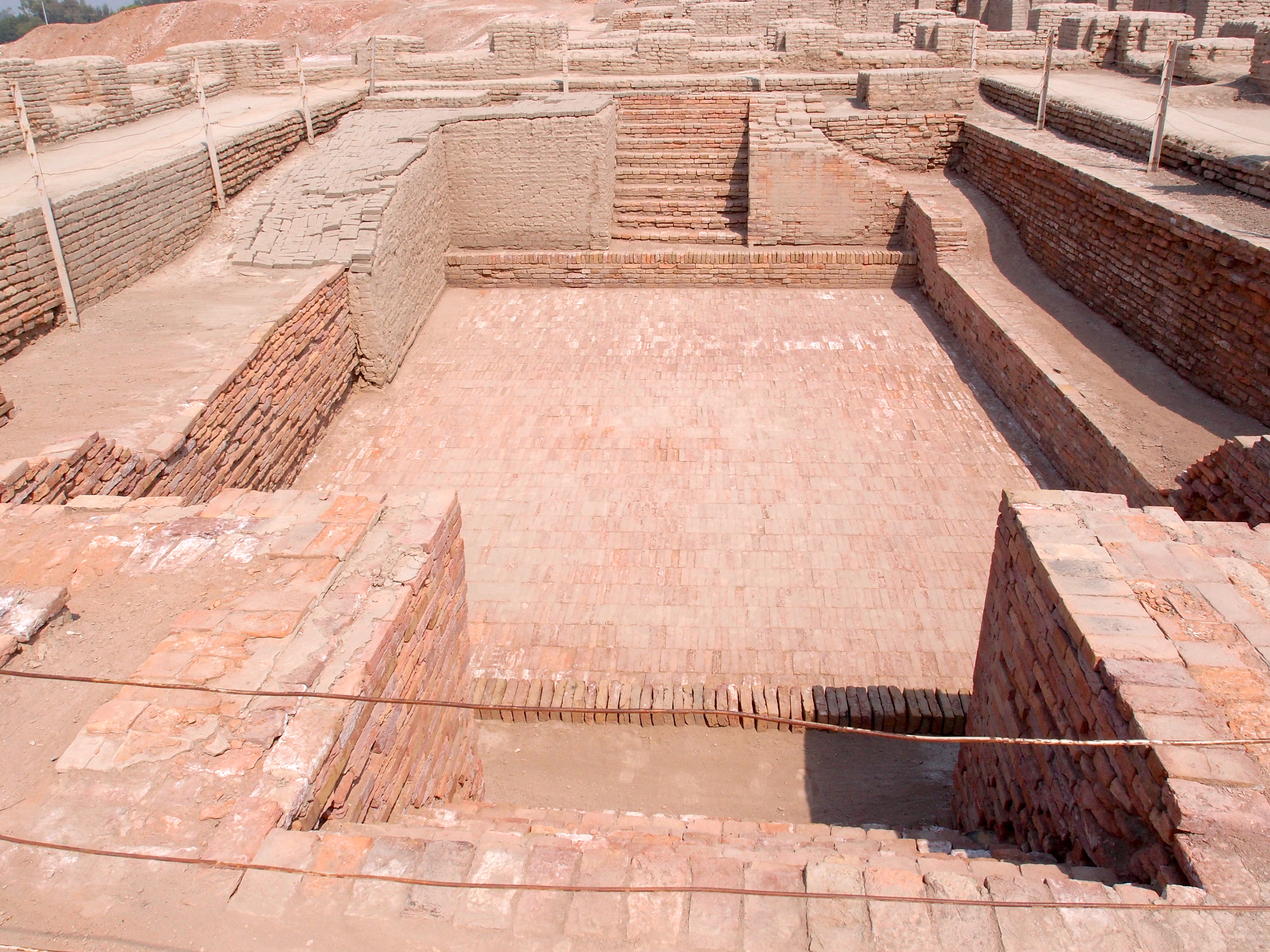
The Great Bath is a good example of how careful this chapter has to be. What is observed: a large, carefully waterproofed public tank with steps, in a raised civic area. What is inferred: ritual purification. The inference is reasonable, partly because ritual bathing has a long later history in India, and it is not evidence. No text tells us.
What is missing, and why it matters
This is the most interesting thing about the Indus civilisation, and it should be stated as an absence of evidence rather than as a positive claim.
No identifiable palaces. No building that is unmistakably a ruler's residence, on the Mesopotamian or Egyptian model.
No temples. No ziggurat, no pyramid, no obvious cult building with an altar.
No royal tombs. Egyptian and Mesopotamian elites were buried with enormous wealth. Indus burials are comparatively modest and fairly uniform, with pottery and some ornaments.
No royal iconography. No statues of rulers, no reliefs of a king smiting enemies, no scenes of tribute or conquest — all of which are ubiquitous in Egypt and Mesopotamia.
Very little that is obviously military. Weapons are present but not abundant; there is little evidence of fortification designed against siege as opposed to flood, and no depictions of warfare.
Two readings, and both are live. The first is that this was a relatively egalitarian society, perhaps governed by councils, merchant guilds or priestly bodies rather than by kings. The second is that the elite simply expressed status in ways that do not preserve — in textiles, in perishable buildings, in ritual authority — and that we are reading absence of evidence as evidence of absence.
What can be said with more confidence: the visible inequality is far lower than at contemporary sites in Mesopotamia and Egypt, and whoever ran this society did not choose to advertise power in the ways every other early civilisation did. That is a genuine and unusual finding.
The economy
Weights are the clinching evidence for organised trade. Indus stone weights follow a strict binary sequence in the lower range, doubling from a base unit, then switching to decimal multiples for larger values. They are consistent across sites hundreds of kilometres apart to within a small fraction of a percent. Somebody was regulating measurement across the whole civilisation — which implies an authority, whatever its form.
Seals are the other diagnostic object.

Made of steatite, hardened by firing, they were pressed into clay to seal goods and bales. Indus seals have been found in Mesopotamia, and Mesopotamian texts refer to trade with a place called Meluhha, generally identified with the Indus region, importing carnelian, ivory, timber, gold and copper. So we have the Indus civilisation named in someone else's records, which is one of the few external anchors we have on it.
Craft production was highly developed. Long carnelian beads, drilled with a specially developed hard drill in a process taking days per bead. Bronze and copper casting, including the famous small figure known as the Dancing Girl. Faience. And cotton — the earliest known cotton textiles in the world come from Mehrgarh and Indus sites, and cotton remained India's defining export for the next four thousand years, a thread Chapter 6.17 picks up with grim consequences.
Standardisation extends to pottery forms, brick sizes, town layout and seal design across an enormous area for six hundred years. That degree of uniformity over that distance and that duration is not seen again in South Asia until modern times.
The script problem, stated honestly
Chapter 3.11 gave the reasons decipherment has failed: inscriptions averaging five signs, no bilingual text, and an unknown underlying language.
The stakes of the arguments are political, and it is worth naming that. If the language is Dravidian, it supports a picture in which Dravidian speakers were the original population of the northwest and were later displaced or absorbed. If it is Indo-Aryan, it supports a picture in which the Vedic culture and the Indus civilisation are the same tradition and there was no significant later migration. Both positions have serious scholars and both attract people whose interest is not scholarly.
The honest current position: undeciphered, most specialists lean toward a Dravidian or a lost non-Indo-Aryan language on the basis of sign statistics and later substrate vocabulary, no decipherment has met the test of predicting readings on texts the proposer did not choose, and anyone presenting the question as settled in either direction is telling you about their politics. Chapter 6.2 handles the linked genetic and linguistic evidence in full.
Why it ended
The old story was invasion. Mortimer Wheeler, excavating in the 1940s, found a group of skeletons at Mohenjo-daro and connected them with Rigvedic references to a god destroying fortifications, proposing that Aryan invaders destroyed the cities. This is no longer accepted, and the reasons are specific. The skeletons come from different levels, not one massacre layer; there is no evidence of burning, of siege damage, or of a new population arriving in the archaeological record at the right time; and the decline was gradual across centuries rather than sudden.
The current picture is a slow unravelling with several contributing causes.
Rivers changed. This is the strongest environmental factor. The Indus and its tributaries shift course (Chapter 1.9). More significantly, a major river system — the Ghaggar-Hakra, along which a very large number of Harappan sites are clustered — dried up. Palaeochannel and sediment studies indicate this was a monsoon-fed river rather than a glacier-fed one, and that as the monsoon weakened it became seasonal and then largely dry. Settlements along it had no water.
The monsoon weakened. Multiple palaeoclimate records — cave deposits, lake sediments, ocean cores — indicate a several-centuries-long weakening of the South Asian monsoon beginning around 2200–2000 BCE, part of the broader 4.2-kiloyear event that also appears in the Egyptian and Mesopotamian records (Chapter 2.8).
Trade contracted. Mesopotamian references to Meluhha decline, and Mesopotamia itself was in trouble at the same time. A civilisation whose cities depended on long-distance craft and trade suffers when the customers disappear.
And people moved rather than died. The archaeology of the Late Harappan period shows settlement shifting east and south — into Gujarat, Haryana and the Ganges-Yamuna region — with smaller sites, more rural life, and continuity in pottery, agriculture and some crafts. The civilisation de-urbanised; the population did not vanish.
One more factor is genuinely uncertain and worth flagging: whether agricultural change played a role. There is evidence that in the later phase, sites shifted toward summer crops such as millets and rice, which suits a different rainfall regime and supports smaller dispersed settlements rather than large cities.
What survived
More than the older textbooks allowed. Several things characteristic of later Indian civilisation appear here first, and the continuity is now taken seriously.
Bathing and water management as a central concern, both practical and probably ritual.
Certain motifs. A seal showing a seated figure with what may be horns, surrounded by animals, has been argued since the 1920s to prefigure Shiva as Pashupati, lord of animals. This is a contested reading — the figure may be a buffalo deity or something else entirely — but the general point that some later Indian religious imagery has Indus antecedents is reasonable.
Crops and animals. Zebu cattle, cotton, sesame, and the agricultural package.
Weights, measures and craft techniques, some of which persist in Indian bead-making and metalworking traditions.
And the genetics. DNA recovered from a skeleton at Rakhigarhi, published in 2019, showed ancestry combining Iranian-related farmer-related populations and South Asian hunter-gatherers, with no detectable steppe ancestry — which is the component that arrives later and which Chapter 6.2 discusses. That single genome is one sample and is treated as such, but it is consistent with the broader ancient-DNA picture from the region.
Where this shows up in your life
Every Indian city's drainage is a comparison the Indus wins. That is a real and uncomfortable observation, not a rhetorical one: covered drains, household connections, waste-water separation and reservoir systems were solved at Mohenjo-daro and Dholavira four thousand years ago, and are unsolved in many Indian cities today. Chapter 6.29 treats urban infrastructure seriously for exactly this reason.
Cotton. The plant was domesticated here, the spinning and weaving technology developed here, and Indian cotton textiles dominated world trade for millennia. The destruction of that industry under colonial rule (Chapter 6.17) and its partial rebuilding are among the central economic stories of modern India.
And a lesson about evidence. This is a civilisation of five million people, with cities, engineering, standardised measurement, long-distance trade and writing — and we do not know what they called themselves, who ruled them, what they believed, or what language they spoke. Everything in Parts 5 through 12 that feels solid feels solid because someone wrote it down and the writing survived and can be read. Remove that and this is what is left.
What the next page covers
The fourth of the great early civilisations developed in near-total isolation from the other three, on a different soil, with different crops, and produced political ideas that still govern a fifth of humanity. Chapter 4.4 covers ancient China — why civilisation there began on wind-blown loess rather than a flood plain, what the oracle bones actually record, how the idea of the Mandate of Heaven made revolution legitimate, and how a period of constant warfare produced Confucius, Laozi and the most durable administrative system ever devised.